The state of Yucatán takes up roughly 1/3 of the Yucatán Peninsula. It borders the ocean on the west and north. In our great loop of the Yucatán Peninsula in December 2014 - January 2015 we visited several sites in Yucatán. Photographs of the Mayan ruins we visited in this state are found at the Ancient Peoples website, www.ancientpeoples.org. General travel and bird photographs are shown here.
MÉRIDA, YUCATÁN, MEXICO
Mérida is a large city and the manner in which the arterials connect with the major highway which encircles the city is not readily apparent at first. The approach for traffic management is different but once you understand it, it works fine.
Merida, Yucatán
Whereas, Campeche had a definite charm, my lasting memory of Mérida is of diesel smoke. The old part of town is easy enough to walk around in but the markets were disappointing (or maybe it was just my mood). Rebecca and I had great dessert in Mérida but the food was pretty standard otherwise. We took a break from standard Mexican fare and had pizza and beer in a plaza which turned out to be a starting spot for a PAN demonstration, that was loud and interesting.
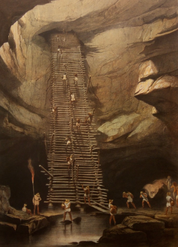
Well at Bolonchen Lithograph by Frederick Catherwood Photographed at the F. Catherwood Museum Merida, Yucatán
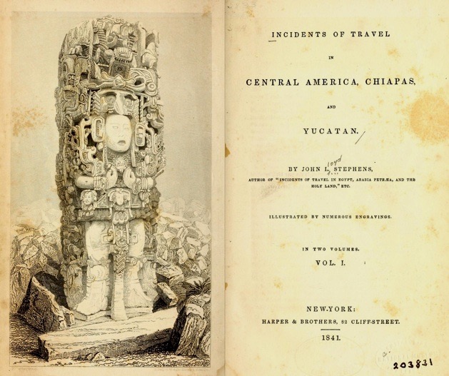
We took a walk down to the Frederick Catherwood museum. Catherwood is famous for his lithographs of Mayan ruins from the early 1840’s. The museum is a row house in Merida, the upstairs has two rooms where a collection of his lithographs are displayed, nothing more. He traveled about southern Mexico and Central America at a time when the ruins were not well known in Europe or North America (which includes Mexico). His major works on the Mayan culture are: Incidents of Travel in Central America, Chiapas, and Yucatan Vol. 1; Incidents of Travel in Central America, Chiapas, and Yucatan Vol. 2; Incidents of Travel in Yucatan Vol. 1; and Incidents of Travel in Yucatan Vol. 2. They were all written by John L. Stevens, Catherwood did the drawings. These books brought the Mayan civilization to the attention of Europe and the United States/Canada.
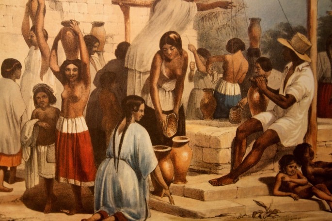
Detail from Well & Building at Sabactsche
Lithograph by Frederick Catherwood
Photographed at the F. Catherwood Museum
Merida, Yucatán
The photograph (above) is of a lithograph (all photos taken from the original lithographs at the museum) of the Well at Bolonchen. It is one of his most famous works and depicts a place that I would like to see some day. The photograph directly above is a detail from the Well and Building at Sabactsche. While at the museum I tended to photograph details from the works rather than the entire work. Catherwood was depicting what he was seeing, not what the Mayan world might have looked like when the ruins were intact. The juxtaposition of the Maya of the mid-1800’s and the ruins was fascinating to me. The photograph is of a lithograph of the Idol of Copán. Copán is a site I have not been to. If you have been diligent in following links, you now know that Smith College Libraries has a nice section on the Mayan works of Catherwood - with some explanatory material.
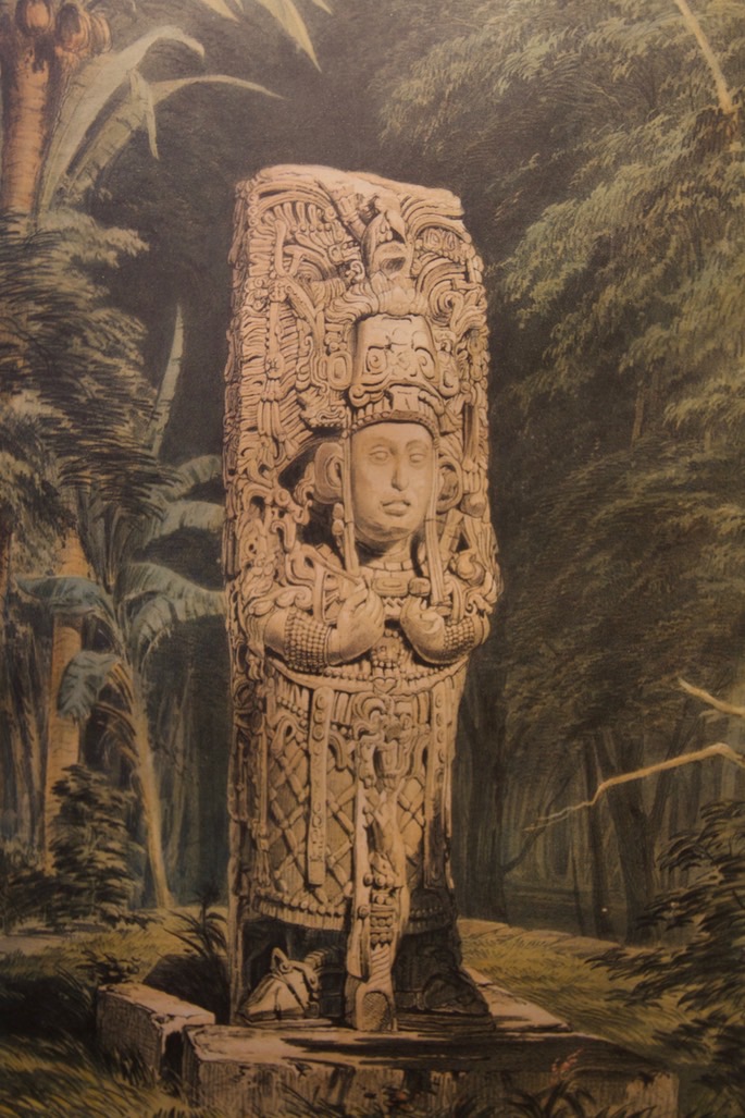
The Idol of Copán
Lithograph by Frederick Catherwood
Photographed at the F. Catherwood Museum
Merida, Yucatán
CENOTES
At this point in our travels we had been on the Yucatán Peninsula for three weeks and not seen one cenote. When I looked down the path to the “sacred cenote” at Chichén Itzá and the swarm of people, I wanted nothing to do with it. Rebecca, wisely - as usual, thought that situation had to be remedied for my mental health. She and I cut our tour of Chichén Itzá short and headed back west to check out all of the cenote signs that had been along the road.
Cenote Xtogil - Yucatan, Mexico
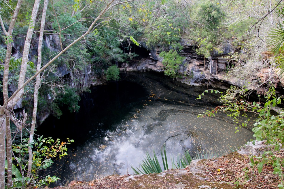
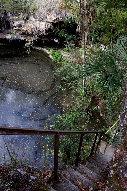
The first cenote we visited was Cenote Xtogil, it proved to be a bit difficult to find (I have no interest in the large commercial cenotes - I was looking for something “real” - meaning there is usually a dearth of signage). After traveling up and down the road where the sign on the main highway had pointed, after ending up at a farmstead called Agua Azul, after muttering to myself a bit, I asked directions in the nearby town. A local provided excellent directions and off we went. After passing a technical school we turned off the secondary road onto a dirt and rock track which led out into the forest, through fields of corn and other crops, and eventually we came to the cenote. My impression is that all of the cenotes are known, and probably named at this point, and generally have some access. This one had some concrete stairs built against the side (photo below) so it was possible to walk down to the water. The walls of the cenote were vertical. In many places there were large alcoves forming small caves in the lower half of the walls. I noted old flow stone (photo below) near the top of one of the caves and wondered at its formation. I noted the hornet nests which were attached to the top of the caves in many places and wondered if the were stingless bees or not. I wondered. I wondered about the people who had used this sinkhole as a source of water. Probably less dramatic than that depicted in Catherwood’s lithograph of the Well at Bolonchen but requiring significant effort none-the-less.
Cenote Xtogil - Yucatan, Mexico
The word cenote is derived from the Yucatec Maya word Ts’onot. There are a lot of cenotes on the peninsula. The peninsula is basically limestone and water dissolves limestone. The process is pretty direct and easily understood, caverns form where the rock is dissolved and sometimes the roof falls in, creating a sinkhole or cenote. There are a large number of cenotes in the northwestern quadrant of the peninsula. A large meteorite crashed into the earth just off shore 66,000,000 years ago. The argument generally presented is that the impact shattered the limestone in this area, making it easier for the ground water to intrude and dissolve the stone. The meteorite also created the Chicxulub Crater and established the boundary between the Cretaceous and Paleogene geologic periods. (It has always been interesting to me that geologic periods are defined by the life forms that lived at that time. In this case, the explosion of material into the air created by the meteorite created significant changes in temperature and the amount of light reaching the earth’s surface - resulting in mass extensions, including the dinosaurs which are the subject of many a children’s book. If only the trumpites read and could understand the impact of climate change.)
Cenote Xtogil - Yucatan, Mexico
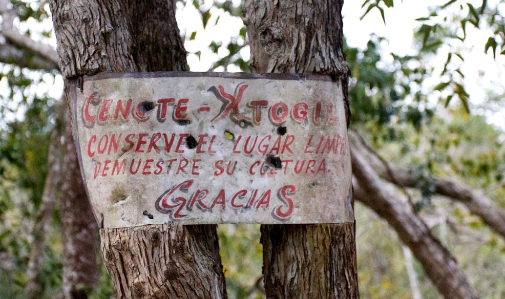
I had seen cenotes from the air, flying low over the jungle in Guatemala but this was the first time I had seen one on the ground, “up close and personal”. During our visit, we were the only people there. As far as the commercial nature of the cenote, the sign above tells it all.
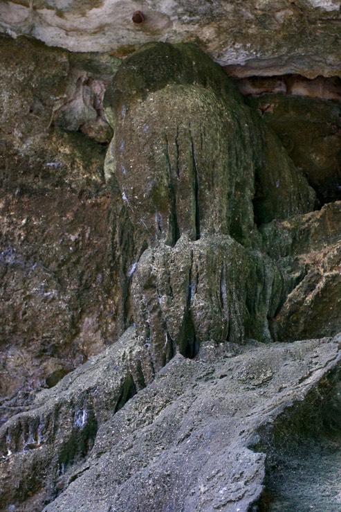
Flowstone - Cenote Xtogil - Yucatan, Mexico
From Cenote Xtogil we headed to Cenote Chihuan, a small commercial cenote (two bottom photos). Again, we were the only ones there during our visit. This “cenote” is a cavern rather than a sinkhole. It was very hot and humid inside the cavern, the owner of the site furnishes life vests so that people can enter the water. The water was a beautiful blue and extremely clear.
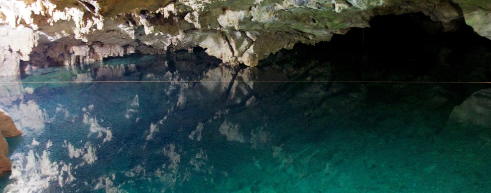
Cenote Chihuan, Yucatan, Mexico
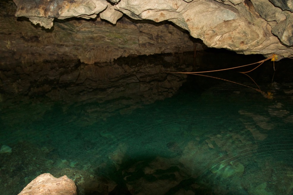
Cenote Chihuan, Yucatan, Mexico
LAGUNA COBÁ
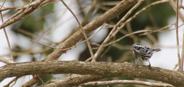
On our last full day in Mexico we traveled southeast from Chichén Itzá and headed to the Mayan site at Cobá (another of those Mexican sites which prohibits tripods). When we arrived the others went into the site and I made a 180° turn and headed to Laguna Cobá. A road borders about half the lake, with all of its attendant traffic and noise. But it provides easy access. A bed of reeds borders the entire lake. If you forget the trash in the lake, the cars driving by a few feet away, and the overhead zip line, it is a very pristine place. It was my last chance for bird video on this trip so I walked the road and the nearby forest. I managed video of a number of species including Velasquez’s Woodpecker (Melanerpes santacruzi dubius) and the Black-and-white Warbler above. The Velazquez’s Woodpecker was once considered conspecific with the Golden-fronted Woodpecker. The dubius subspecies is found on the Yucatán Peninsula and adjacent areas in Belize and Guatemala.
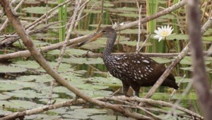
When we met again, the rest of the group described a Limpkin which they had seen near a lake in the Cobá site (it was to this lake that I had wanted to go but rules are rules, no tripods). Limpkin were also in the reed beds around the lake.
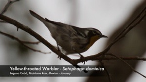
In the trees there were a number of warbler species. A number of them summer in the United States and Canada and winter in Mexico, like the Yellow-throated Warbler shown here.
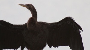
I first saw Anhinga in the Everglades of Florida, USA. Since then I had seen this species in wetlands throughout sub-tropical and tropical America, but the one I recorded here was the first I had seen on this trip (framegrab below).
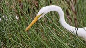
Great Egrets are common birds in the America’s but the one I saw at Laguna Cobá holds the record for standing motionless for the longest time. I never did see it catch what it was hunting, I grew tired.
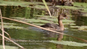
Another common bird of the America’s, the Pied-billed Grebe was also at the lake.
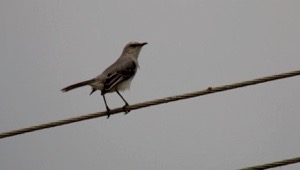
Tropical Mockingbirds were singing loudly from the overhead wires. They differ in appearance from the Northern Mockingbird by the lack of a white wing patch.
After a couple of hours it began to rain and I eventually made my way to a roadside cafe. One of those places where I had barbecued chicken, potatoes, and salad. I also ordered a soft drink and saw the owner’s son head off to the store, soon I had my soft drink but was careful in opening it, after all it had just been on a bike ride. Since I was the only guest the owner came out to see how things were and we settled into conversation. He was Mayan and spoke both Spanish and English. We discussed just about everything we could think of for about half an hour. He was well informed on the travel patterns of tourists, which airlines were flying into Cancún and how often, when the Canadians come, and when the Europeans come, for instance. We discussed the ruins which had been cities and which had been ceremonial centers. We discussed the education his son was getting. We discussed the world. Very, very enjoyable. It was the perfect way to end my trip to Mexico.